Aster Heights
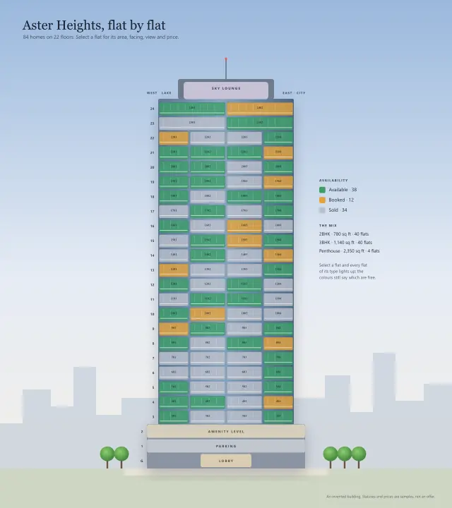
The site: 88 homes on 22 floors over a two-level podium, at the corner of Station Road and Tower Avenue.
- Homes
- 88
- Floors
- 22 residential, over a two-level podium
- Corner of
- Station Road and Tower Avenue
A location map for a development: schools, transit and shops by distance, grouped by what they are for.
The same content as the picture, as text: every part and what it says when you open it.
The site: 88 homes on 22 floors over a two-level podium, at the corner of Station Road and Tower Avenue.
Forty hectares of water on the west side of the tower, which is why the west-facing flats have the lake. 3.1 km away: 12 minutes by car.
A three-kilometre path along the shore, lit at night, with benches and two cafés. 3.0 km away: 11 minutes by car.
Lawns, a children's play area and a running loop under old rain trees. 2.4 km away: 9 minutes by car.
An eighteen-hole course with a clubhouse; membership is separate. 4.5 km away: 16 minutes by car.
A day school from kindergarten to year twelve, with its own playing field. 1.4 km away: 22 minutes on foot.
An international school teaching to the IB diploma. 3.1 km away: 12 minutes by car.
A university campus of engineering, design and business, with a public library. 3.8 km away: 14 minutes by car.
A 400-bed multi-speciality hospital with a 24-hour emergency department. 2.1 km away: 33 minutes on foot.
A family clinic and pharmacy, open late. 1.4 km away: 22 minutes on foot.
Two hundred shops, a supermarket, a food court and an eight-screen cinema. 2.5 km away: 10 minutes by car.
A high street of everyday shops, bakeries and a Sunday farmers' market. 1.0 km away: 16 minutes on foot.
Line 2, every five minutes at peak; Central is four stops away. 0.9 km away: 15 minutes on foot.
Line 2, with a covered walkway into the mall. 1.8 km away: 29 minutes on foot.
Line 2 interchange with the airport line. 3.5 km away: 13 minutes by car.
Office campuses for about 30,000 people, most of them in technology. 3.1 km away: 12 minutes by car.
The city's financial district: banks, law firms and the stock exchange. 4.0 km away: 14 minutes by car.
International airport, 35 minutes by car or 28 by the airport line from Tech Park.
Townships, towers, masterplans and leasing plans, unit by unit and by status.